


Les Halles

vaud
User

Length
11.5 km

Max alt
678 m

Uphill gradient
255 m
Km-Effort
14.9 km

Min alt
587 m

Downhill gradient
255 m
Boucle
Yes
Creation date :
2024-06-17 16:23:17.914
Updated on :
2024-09-02 07:45:32.115
3h23
Difficulty : Difficult

FREE GPS app for hiking
 SityTrail
IGN / Geographical institutes
SityTrail Plus
The world is yours!
About
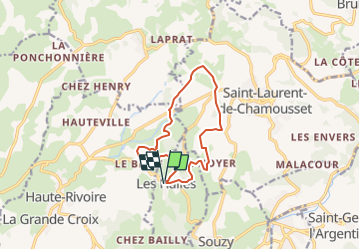
Trail Walking of 11.5 km to be discovered at Auvergne-Rhône-Alpes, Rhône, Les Halles. This trail is proposed by vaud.
Positioning
Country:
France
Region :
Auvergne-Rhône-Alpes
Department/Province :
Rhône
Municipality :
Les Halles
Location:
Unknown
Start:(Dec)
Start:(UTM)
611306 ; 5063845 (31T) N.
Comments